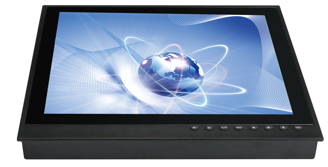
全球全系統(tǒng)導(dǎo)航定位接收機(jī)是一臺(tái)新型的、集多種wxdw系統(tǒng)、遇險(xiǎn)避碰系統(tǒng)于一體的多功能導(dǎo)航定位接收機(jī);其體積小,重量輕,安裝方便。輸出信號(hào)符合IEC61162-1國(guó)際標(biāo)準(zhǔn),能滿足我國(guó)軍、民用船舶導(dǎo)航定位設(shè)備的要求。是目前{wy}一款全功能的多系統(tǒng)定位接收機(jī)。
一、主要特點(diǎn)Main features
1、 中國(guó)北斗系統(tǒng)(COMPASS)定位功能;
China Beidou System(Compass)-Positioning function
2、 美國(guó)全球定位系統(tǒng)(GPS)定位功能;
US Global Positioning System(GPS)-Positioning function
3、 歐洲伽利略系統(tǒng)(GALILEO)定位功能;
European Galileo System(GALILEO)-Positioning function
4、 俄羅斯導(dǎo)航定位系統(tǒng)(GLONASS)定位功能;
Russia Global Navigation Satellite System(GLONASS)-Positioning function
5、 廣域衛(wèi)星差分增強(qiáng)系統(tǒng)(SBAS)功能;
Satellite-Based Augmentation System(SBAS)-function
6、 船舶自動(dòng)識(shí)別系統(tǒng)(AIS)功能。
Automatic Identification System(AIS)-Positioning function
DGPS就是差分GPS(Differential GPS)是在正常的GPS外附加差分改正信號(hào),此改正信號(hào)改善了GPS的精度。差分定位(Differential Positioning),也叫相對(duì)定位,是根據(jù)兩臺(tái)以上接收機(jī)的觀測(cè)數(shù)據(jù)來(lái)確定觀測(cè)點(diǎn)之間的相對(duì)位置的方法,它既可采用偽距觀測(cè)值也可采用相位觀測(cè)值,大地測(cè)量或工程測(cè)量均應(yīng)采用相位觀測(cè)值進(jìn)行相對(duì)定位。
DGPS is Differential GPS,it’s appended to the differential correction signal outside the normal GPS,the correction signal improve the accuracy of GPS.Differential Positioning also means Relative positioning,it is the method of relative position between the observation point,which is determined according to the observation data of more than two receivers.It can be used Pseudo-range observations or phase observations,geodetic survey or engineering survey is used the phase observations to position.
SBAS 即Space Based Augmentation System (DGNSS/DGPS/WAAS/EGNOS) 是利用地球靜止軌道衛(wèi)星建立的地區(qū)性廣域差分增強(qiáng)系統(tǒng)。
SBAS:Space Based Augmentation System(DGNSS/DGPS/WAAS/EGNOS) is a regional system,which is used Geostationary satellites(GEO) to establish.
目前全球SBAS系統(tǒng)有:
Currently,The global SBAS system include:
1. 歐空局接收衛(wèi)星導(dǎo)航系統(tǒng)(EGNOS),覆蓋歐洲。
European Geostationary Navigation Overlay Service,Covering Europe.
2. 美國(guó)雷聲公司的廣域增強(qiáng)系統(tǒng)(WAAS),覆蓋美洲。
US Wide Area Augmentation System(WAAS),Covering America.
3. 日本的多功能衛(wèi)星增強(qiáng)系統(tǒng)(MSAS),覆蓋亞洲。
Multi-functional Satellite Augmentation System(MSAS),Covering Asia.
4. 印度的GAGAN 127,128,覆蓋亞洲及印度洋。
GPS Aided Geo Augmented Navigation (GAGAN),Covering Asia and the Indian Ocean .
所以,在全球大部分區(qū)域使用這臺(tái)接收機(jī),其定位精度可達(dá)到1米。
So,this receiver can be used in most parts of the world,and the positioning accuracy can reach 1 meter.


二維碼")
版二維碼")

導(dǎo)航定位接收機(jī)(GN-61)")
導(dǎo)航定位接收機(jī)(GN-61)")
導(dǎo)航定位接收機(jī)(GN-61)")